Contents
Air Masses
It is defined as a quantity of air with dimensions of about 500nm or so, with little or no horizontal variation of any of its properties, especially temperature. Air masses are named after the sources from which they originate. Main air masses on the Earth are Tropical Air Masses and Polar Air Masses. Changes in the weather are caused by the movement of air masses.
Factors affecting the properties of an Air-Mass
- Source region – if the air mass is of Polar origin, it will be cold and if of tropical origin, it will be warm.
- Its track over the Earth’s surface – if it passes over large expanses of water, it will be moist and if it passes over land, it will be dry.
- Its extent of convergence or divergence – if it converges at a low level (as in depression) it will cause the air in the centre to ascent. If it diverges at lower levels (as in anti-cyclone) it will cause the air from above to descend.
- Its age – the age of the air mass is the number of days it has spent in its source origin. The longer it has stayed there, the greater it will be influenced by the climate of that place.
- Its rate of travel – if it moves quickly, the area over which it moves does not have sufficient time to influence the properties of the air mass. Hence a quick-moving air mass almost retains its original properties. If it moves slowly, the area over which it blows has sufficient time to influence its properties. Hence a slow-moving air mass will have somewhat different characteristics from its original ones.
Classification of Air Masses:
- Polar Continental – Polar air mass coming over land. (Cold & dry)
- Polar Maritime – Polar air mass coming over sea. (Cold & Moist)
- Tropical Continental – Tropical air mass coming over land. (Warm & dry)
- Tropical Maritime – Tropical air mass coming over sea. (Warm & Moist)
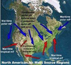
Source regions of Air Mass
They are represented on maps with a two-letter symbol. The first letter indicates the moisture level of the air mass, and the second letter represents the temperature of the air mass.
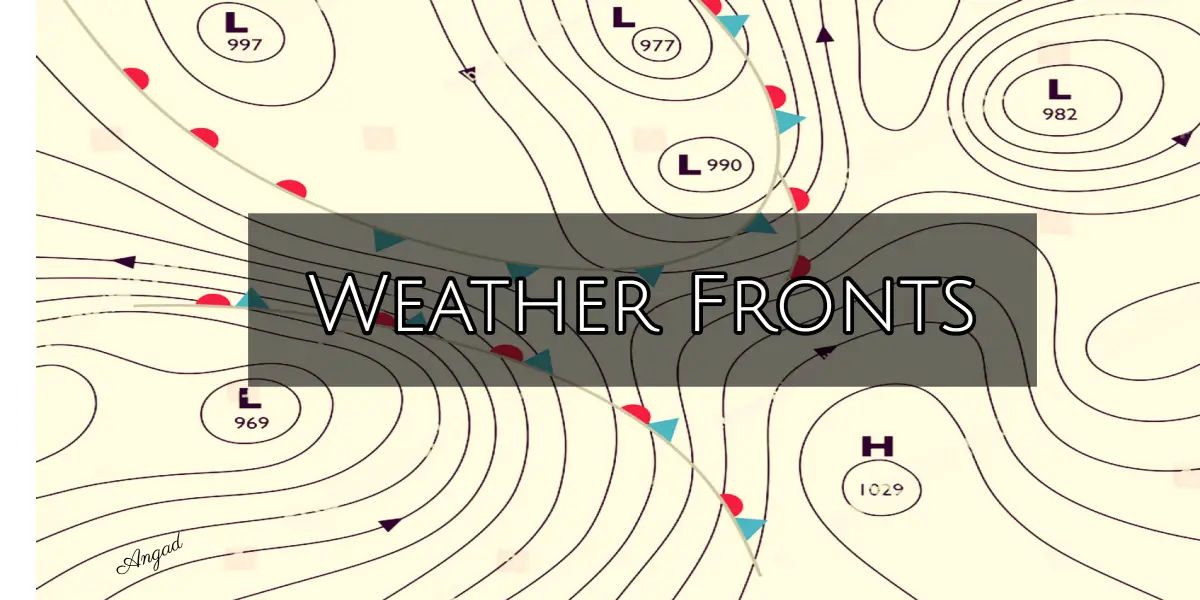
FRONT
The boundary between two adjacent air masses which are well defined by their different characteristics is called a front. The two air masses should have different density, pressure and temperature and should have originated from different source regions of different latitudes.
The type of front depends on the following:
- The direction in which the air mass is moving
- The characteristics of the air mass.
TYPES OF FRONT
On the basis of Direction in which the air mass is moving
- Arctic Front – It is located between the very cold arctic air and less cold polar air. The temperature difference across the front is small, contrasts are therefore small. The circulation activity connected with this front is weak.
- Polar Front – It is located between the Polar Air and the Tropical air and is the most active front with large contrasts in the physical properties of the air masses. It is very vigorous in behaviour.
- Inter-tropical Front (ITCZ Front) – It is found in the Inter-Tropical Convergence Zone (ITCZ) between the opposing trade wind belts. It has a very small contrast in the physical properties of the opposing air masses. The frontal activity is very weak.
On the basis of the characteristics of the air mass

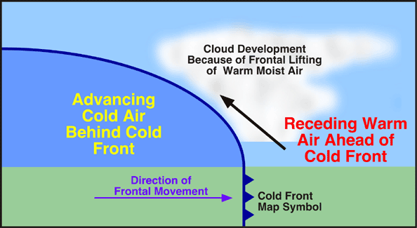
Cold Front
– Picture Courtesy: https://climate.ncsu.edu/Cold Front – After a front passes over a place, if the atmospheric temperature is lower than before, the front is called a cold front. They tend to move faster than all other types of fronts. They move the farthest while maintaining their intensity. They are generally associated with the most violent weather among all types of fronts. They have associated with strong thunderstorms along & ahead of the front and a broad area of clouds immediately behind the front. They are usually associated with squall lines which are a line of strong thunderstorm parallel to and ahead of the front. They usually bring cooler weather, clear skies and sharp changes in wind direction. On weather maps, blue line denotes cold front. In facsimile, conical symbols (like icicles) are used to denote cold front.
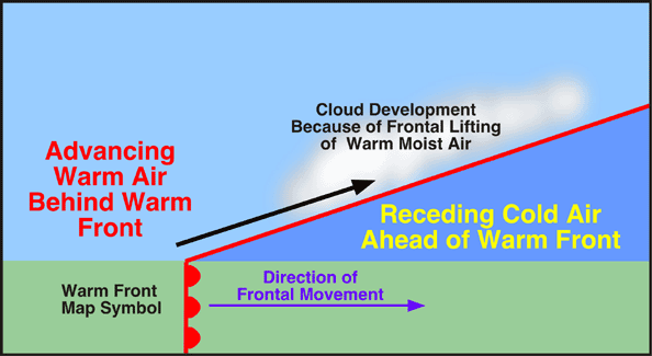
Warm Front
– Picture Courtesy: https://climate.ncsu.edu/Warm Front – After a front passes over a place, if the atmosphere temperature is higher than before, the front is said to be a warm front. The warm front has a gentler slope than the cold fronts. Warm fronts tend to move slowly. They are generally less violent than cold fronts. They are generally associated with large regions of a gentle ascent, stratiform clouds and light to moderate continuous rain. Behind the warm front, the skies are relatively clear. A warm front if exists on a weather map, it will be to the NE of a cold front and often, to the East of a surface low-pressure area. On a weather map, red line denotes warm front. In facsimile, rounded symbols (like heat boils) are used to denote the warm fronts.
- Occluded front – A type of frontal boundary that occurs when the cold front catches up with the warm front. If a fast-moving cold air mass overtakes a slower-moving warm front and then continues advancing and catches another cold front, an occluded front forms. Weather associated with the occluded front is similar to the weather associated with a cold front.
- Stationary Front – When a cold air mass and a warm air mass parallel each other with little horizontal movement, stationary front forms. Weather is similar to a warm front, although it may possibly last a long time.
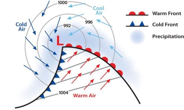
FRONTAL DEPRESSION
Frontal Depression – PC: https://www.allatsea.net/
- A frontal depression is a low-pressure area formed at the boundary between two different air masses. It occurs in middle or higher latitudes. Series of the following one after the other is known as ‘family of frontal depressions’.
- The formation of a frontal depression is called ‘frontogenesis‘.
- The warm air must travel faster than the cold air or both must travel in opposite directions.
- The front depression starts a small bulge of warm air in the cold air. The bulge then increases in size and the isobars in the cold air begin to bend accordingly.
- Since the density of warm air is less than that of the cold air, the bulge is an area of low pressure surrounded by areas of high pressure on three sides.
- The bent isobars take closed shapes and the winds blow spirally inward, anticlockwise in the Northern Hemisphere.
- The isobars inside the bulge remain straight and roughly parallel to the original boundary between the two air masses.
- On crossing the front, the isobars change direction by 90 degrees. Because of this, when a front passes over a place, the wind suddenly veers by 90° in the NH and backs by 90° in the SH.
- The entire system will move in the same direction as the warm air mass and with approximately the same speed as the warm air mass.
Weather Associated with Frontal Depression:
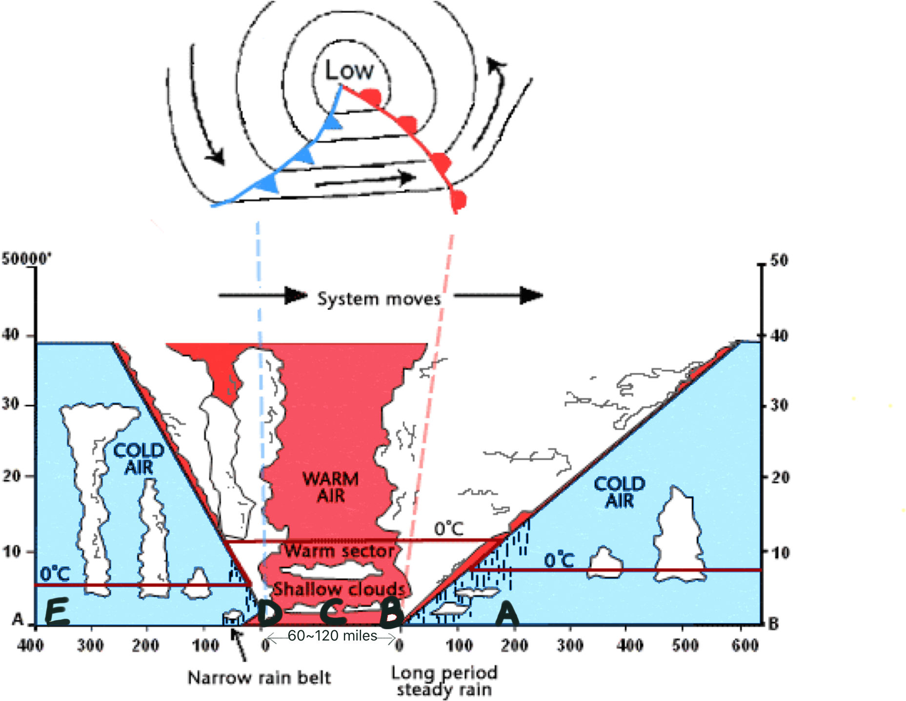
Weather Sequence on the passage of a Frontal Depression in NH
A) At Point ‘A’: Well before the warm front
- Atmospheric pressure falls steadily.
- Wind direction is steady and wind force is increasing.
- Temperature is slowly rising.
- There is continuous heavy rain or snow.
- Visibility is good except during showers.
B) At Point ‘B’: Just before the Warm Front
- Atmospheric pressure stops falling and becomes steady.
- Wind suddenly veers by 90° (backs in SH)
- Wind force becomes steady.
- Temperature suddenly rises quickly.
Precipitation stops, but mist or fog is present, because of which, visibility is poor.
C) At Point ‘C’: After the Warm Front, before the Cold Front
- Atmospheric pressure is constant.
- Wind direction, wind force and temperature are all steady.
- Sky is cloudy and there is drizzle, fog or mist, because of which, visibility is poor.
D) At Point ‘D’: At the Cold Front / Just after Cold Front passes
- Atmospheric Pressure suddenly rises
- Wind suddenly veers by about 90°. (backs in the SH)
- Wind force is significantly high giving rise to squalls.
- The temperature suddenly falls.
- There is heavy rain, thunder and lightning.
- Visibility is poor due to rain squalls.
E) At Point ‘E’: Well after the Cold Front passes
- Atmospheric pressure rises slowly.
- Wind direction becomes steady again.
- Wind force gradually decreases & temperature becomes steady.
- There are occasional showers, during which the visibility is poor. Otherwise, visibility is very good.
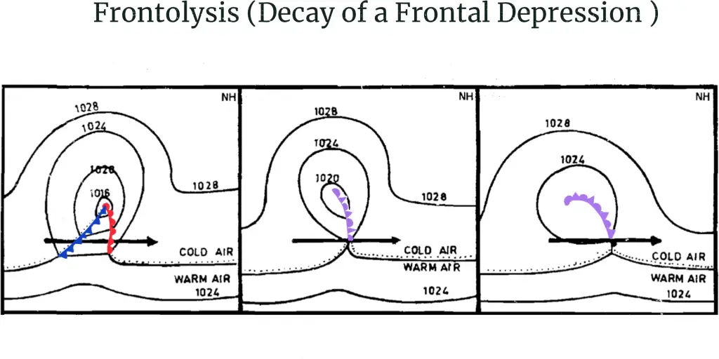
FRONTOLYSIS
Frontolysis is the decay or weakening and final dissipation of a frontal depression.
- The first step is the formation of ‘occlusions’.
- The cold air in front of and behind the warm sector of a frontal depression soon manages to undercut the warm air and lift it completely above the sea level. The depression is then said to be occluded.
- There are three stages of decay of a frontal depression. These are shown below:

Frontolysis – Decay of a frontal depression
- If after the passage of an occlusion, the air temperature is lower than before, the occlusion is said to be cold occlusion.
- If after the passage of an occlusion, the air temperature is higher than before, the occlusion is said to be a warm occlusion.
- On the passage of an occlusion, the wind veers more for cold occlusions than for warm. (backs in SH)
- Weather associated with warm and cold occlusions is similar to that of the warm and cold front but just milder.
- Within a few days of the occlusions, the frontal depression fills up and is no longer visible on the weather maps.
It would be interesting to read Clouds – Formation and Ten different Types. Weather associated with Frontal Depression and Frontolysis is sourced from Marine Meteorology book by Capt. Subramaniam for study purposes only.
the website is very fantastic, i love it
please help me join